During the flood season, under the organization and leadership of relevant emergency response units, members of DJI emergency rescue Alliance all over the country responded quickly, gave full play to the technical advantages of drone, deeply interpreted the multiple applications of drones in the front line of flood control and disaster reduction, and provided efficient guarantee for flood control operations.
Satellite images show Yang Jiacang village in Jiangxi surrounded by water on three sides, like a sharp knife into the intersection of the Yangtze River and Poyang Lake. The terrain is very dangerous. Under the scour of successive rainstorms, the water level continues to rise, and the levee is faced with great challenges. once the breach occurs, the consequences are unimaginable.
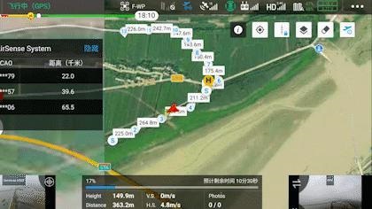
On July 16, under the leadership of the emergency response unit, dJI industry application engineers who went to the scene to support quickly took action, using the longitude and latitude M300 RTK solidified key sections of the inspection route, and through the mounted Zen Thinking H20T zoom screen to view the details of the embankment.
During the flood discharge period, 2d orthographic images of the site shall be rapidly produced for flood assessment and command and dispatch as required by relevant units. On the other day, it continued to rain in The Wangjiaba area, and the wind was up to level 7 in the airspace above 300 meters, which posed a great test to the operational ability of drone in wind and rain.
Jingwei M300 RTK was ordered to take off in the rain. After taking off in the rain, the Zen Thinking H20T wide-angle camera carried on the automatic normal image data collection for the operating area of about 0.8 square kilometers on the site.

