1. Transmission line planning
In all kinds of power station transmission line corridor planning, the unmanned aerial vehicle mapping system is used to carry out detailed mapping of the planned area and obtain relevant reference data quickly and accurately, which can effectively reduce the impact of adverse environment on the ground site survey work. Through data analysis, we consider related factors, coordinate the relationship of each project, make full use of the limited channel resources, and make the route direction and regional planning more reasonable.
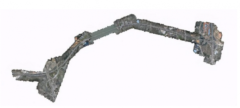
2. Topographic map survey
UAV mapping is suitable for topographic mapping of large scale, and the mapping scale is usually 1:2000. However, in the feasibility research and design stage of power grid engineering, the method of adding field control vehicle and using field measurement data to optimize aerial survey elevation information can be used to obtain 1: The topographic map of 1000 scale provides detailed basic data such as image elevation for site layout and optimization, thus reducing the intensity of surveying and mapping work and greatly improving the planning efficiency.
3. Application in routine line inspection
Domestic power experts pay more and more attention to the modernization of patrolling maintenance. In fact, as early as the 1950s, European and American countries have begun to study and use unmanned aerial vehicles to complete live patrolling operation and line construction.
4, disaster emergency response
In recent years, China has been tested by extreme weather such as flood, high temperature and cold. Natural disasters such as flood, debris flow and freezing caused by this have exerted extremely adverse effects on the local power infrastructure. Therefore, it is very important to carry out real-time detection on the actual working conditions of these infrastructure.
5. Line erection
In the erection process of high voltage power lines, it may be necessary to pass through some obstacles such as live high voltage lines, canyons, valleys, trees, buildings and so on. Although the operation efficiency of traditional electric power cable is high, it also has the disadvantages of difficulty and high risk coefficient. UAVs electric cable system has the advantages of high operating efficiency, strong adaptability, long cable distance and high safety factor.
6. Development direction
(1) Professional surveying camera, usually using a professional surveying camera with stable internal azimuth elements and small lens distortion;
(2) The camera is equipped with large array CCD, which greatly improves the working efficiency of the UAV;
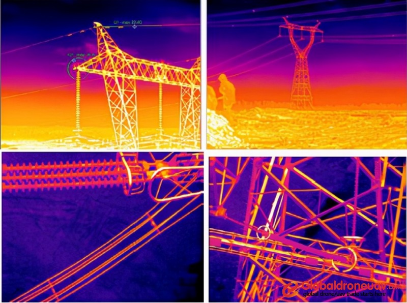
(3) The UAV can be equipped with new measuring equipment such as visible light, infrared camera or laser ranging to meet different mapping requirements.
(4) The camera can simultaneously realize photogrammetry of different wavelengths such as visible light and infrared, which effectively improves the working efficiency of the UAV system;
(5) The camera is required to have zoom function. When a suspicious target is found, it can be gazed at and observed, which can improve the identification ability of fault targets during line patrol. With the continuous progress of UAV and aerial survey technology, UAV surveying and mapping system will play a greater role.
Chengdu Yuanshi has been committed to the two - and three-dimensional GIS technology and UAV aerial survey services for many years. In terms of GIS, the system platform is deeply combined with the industry needs, and now we have a complete industrial solution in the fields of simulation, land asset management, population information management, smart mine, smart scenic spot/park and so on. In the aspect of UAV aerial survey, the company has many years of aerial survey experience in Southwest China, and now it has the production capacity of DLG, DOM, DEM, DRG, 3D real model and the complete set of data results of airborne laser radar.

